
It is a place where the sea seems to hold memories: phantom beacons, shipwrecks turned into legend, memories of corsairs and pirates, in a historical confusion that still hasn't been cleared up... like the mist of the Atlantic
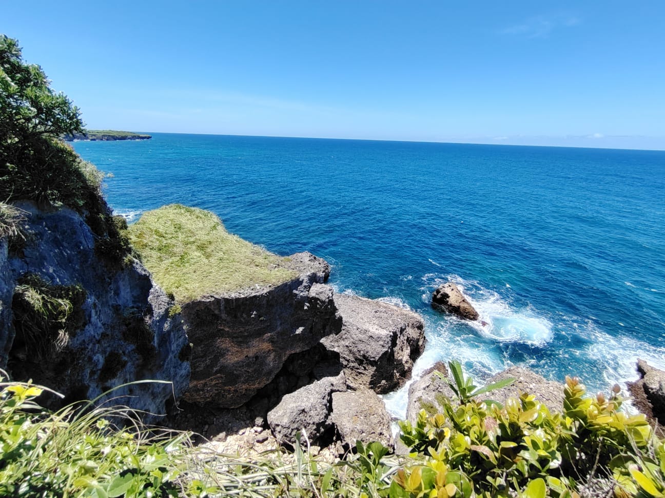
CABRERA. – Cabo Francés Viejo rises from the Atlantic like an enormous stone prow defying the wind. The promontory, formed by ancient coral terraces built up over millennia in the northeast of the island, drops abruptly into limestone cliffs where the sea crashes with a constant and ancient violence.
The rock, eroded by salt and time, opens into cracks and walls from which the ocean seems infinite, and there, geology and landscape merge to such a level that the visitor does not know if the reef became a mountain or if the seabed rose up looking for the sky.
The cape has something of a natural border, of the last land edge before everything is just waves, the sound of the wind and salt.
From Cabo Francés Viejo, the ocean appears serene, but the currents and high tide deter even the bravest. (Source/Solangel Valdez).
Close your eyes for ten minutes. That's how long it takes to go from the hot asphalt of the Cabrera-Río San Juan highway to standing before the raw ocean. The trail, part of a subtropical rainforest, is short and requires sneakers, constant attention, water to drink, and a willingness to listen to the silence or feel how the air muffles words that find no echo.
It's just you and the path covered by the gloom offered by an almost impenetrable botanical canopy and, at the end, a verdant esplanade where the light explodes and the sea breaks down into impossible blues that change according to the time of day.
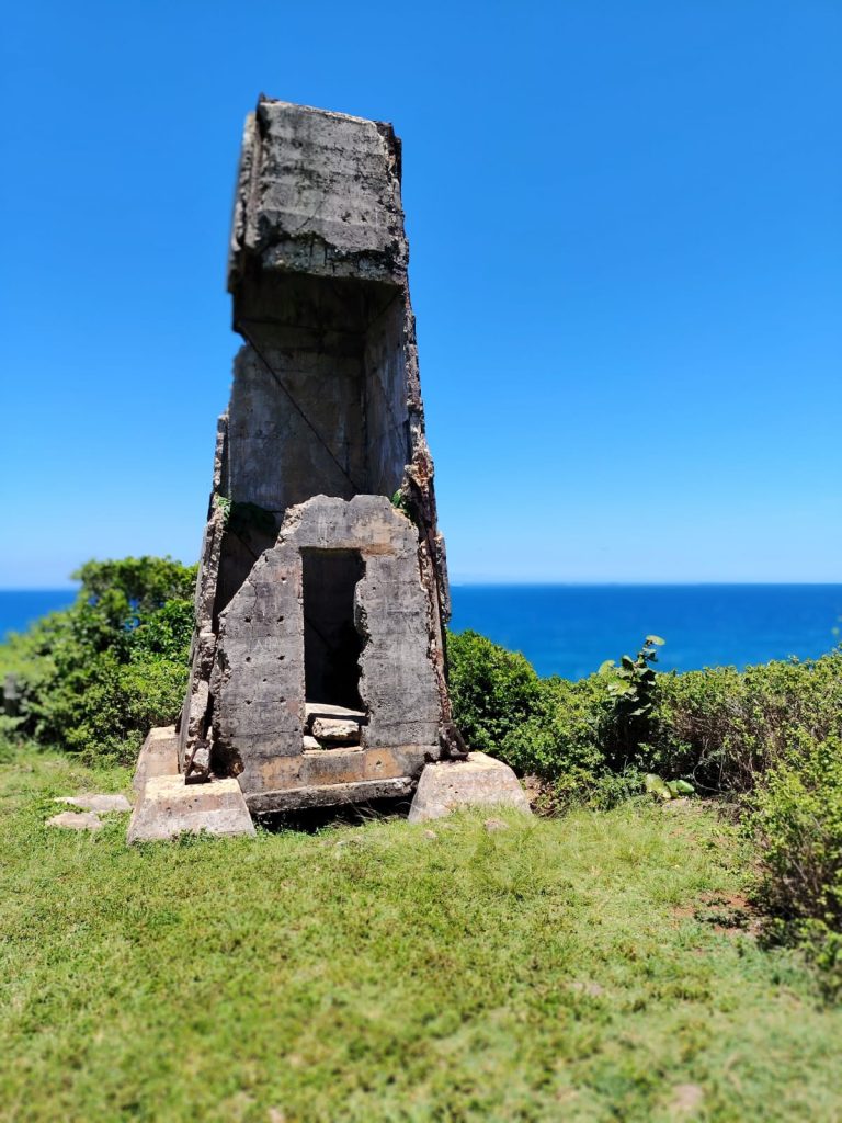
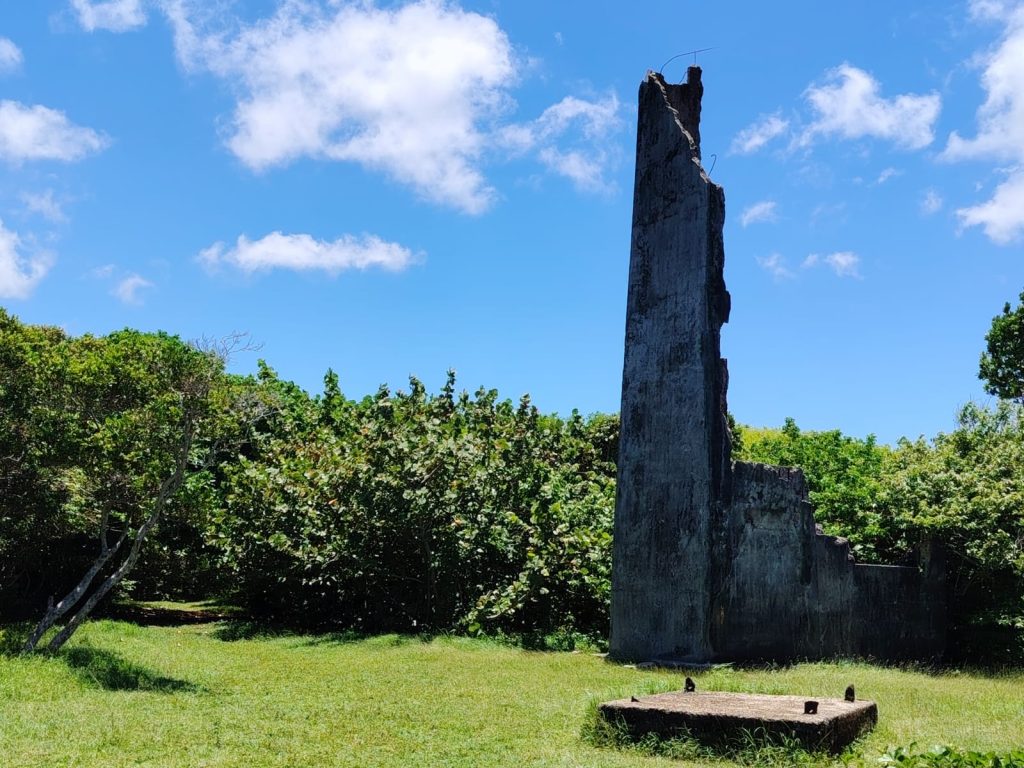
And the remains of three lighthouses or beacons, some with more than a century and a half of history, add an almost ghostly aesthetic and atmosphere to the scene.
The Atlantic holds the memory
In elementary school geography class, the teacher would gloss over the geographical features of the north coast: Cabo Cabrón, Punta Rucia, El Morro, Cabo Samaná, and Cabo Francés Viejo. She would explain their geological origin and their importance for navigation. Nothing more.
One day, driving from Nagua toward Río San Juan, in the community of Abreu, you see the sign, your childhood memories come flooding back, and you feel curious to see that promontory that looked like a scribble on the map.
A booth from the Ministry of Environment informs you that the place has been protected since it was declared a National Park on May 2, 1974, through Law 654 aimed at preserving coastal areas of high ecological and scenic value, according to the records of the National System of Protected Areas (SINAP).
There you'll be greeted by Tito, who has a unique way of interpreting the world. Always smiling, he'll recite the rules without pausing and will end by telling you that some visitors give him "up to 400 pesos" if he accompanies them. He'll also warn you that if it has rained, no one is allowed in: the area is closed for safety reasons.
The Atlantic reigns supreme without asking permission. With nothing to tame it, it has crashed against the rock so many times, for so many centuries, that it ended up sculpting it in the most capricious way.
The coastal plateau of approximately 1.5 km² overlooks the ocean with cliffs of more than 20 meters of free fall, as described in environmental fact sheets and geomorphological studies.
An old Frenchman and pirates?
The story behind the name is shrouded in a fog of conflicting accounts, as is the case with much of the Dominican Republic's coastal history. Local tradition, recorded by park rangers, fishermen, and chroniclers, maintains that the place was named by an elderly Frenchman who lived in the area during colonial times.
Another version, transmitted orally and repeated in tourist reports and community testimonies since the end of the 20th century, claims that this old man was the captain of a French ship called Breton that ran aground in these waters, and from there comes the toponym for the community and a disturbing beach: El Breton.
Without conclusive documentary evidence, all that remains is to enjoy the scenery and keep in mind that this place is a product of the intense French presence on the north coast of Hispaniola since the 17th century, as documented by Frank Moya Pons in Manual de Historia Dominicana and in his studies on the French occupation of the west of the island.
And it wasn't accidental. According to the dynamics described by Roberto Cassá in his research on the colonial economy and smuggling in Hispaniola, those coasts, from Puerto Plata to Samaná, passing through Cabrera and Río San Juan, functioned as a maritime corridor for illicit trade, the hunting of wild cattle, the logging of precious woods, and the movement of European privateers vying for control of the Caribbean. It was a dynamic of almost constant piracy and smuggling.
A place with its own history
Tito won't tell you any of this, because he barely went to school. But by piecing together the fragments, you can reconstruct the story of Cabo Francés Viejo, that natural balcony located about three kilometers from Cabrera. A place where the silence is heavy and time has accumulated beauty and history.
Before becoming a protected Natural Monument, a tourist trail, or a location for photographs, this cape was a reference point for sailors, a lookout point for the coast, and the scene of colonial disputes between the French, English, Spanish, privateers, and illegal traders.
In the popular memory of the region, the idea of a "battle between the French and the English" frequently appears, which over time ended up being mistakenly identified as "the Battle of the Lemonade".
The confusion seems to stem from the phonetic similarity to the Battle of La Limonade, which took place in the north of the island during the 17th century and is mentioned in studies of Saint-Domingue and in colonial descriptions compiled by Moreau de Saint-Méry. However, historical records place that episode in the territory of present-day Haiti, not on the coast of Cabrera.
That said, in Cabo Francés Viejo there survives an oral tradition about naval clashes and powers that killed each other for control of this maritime strip, in a region marked by smuggling and conflicts in the colonial Caribbean.
The Dominican northeast was a strategic route, since from these waters ships could be watched, anchorages protected and small inlets useful for resupplying ships could be controlled.
Watchers of the times
If anything visually defines Cabo Francés Viejo, it's the beacons, which everyone calls lighthouses. From afar, they look like remnants of a maritime apocalypse. Up close, you can see centuries of navigation.
At the cape, there are remains of three structures built at different times. Visitors often call them "the three lighthouses," although technically some only functioned as coastal navigation beacons.
The first one, according to accounts gathered by chroniclers, was built more than a century ago with iron and gravel. It was a rudimentary structure, typical of a time when navigation still depended on basic visual references and the recognition of the coastline.
The second one was reportedly built during the Trujillo Era, as part of the regime's partial modernization of maritime infrastructure, according to oral accounts gathered from residents and former watchmen in the area. Its design already reflected more modern maritime signaling requirements.
The third one dates from more recent times. Local accounts indicate that an earlier structure was deteriorated by saltpeter and replaced during the government of Hipólito Mejía by another metal tower, of which only the concrete foundation and four metal supports remain.
The structures remained visible for years, a reminder that the Dominican north coast, with its reefs, coral shoals, changing currents and cliffs exposed to the Atlantic, has historically been considered one of the most complex areas for navigation in the insular Caribbean, as noted in the "Sailing Directions for the Island of Santo Domingo", originally published by Emilio Rodríguez Demorizi in 1975 and updated decades later by Miguel Reyes Sánchez for the Dominican Navy.
In those technical pages, designed for sailors and navigators, Cabo Francés Viejo appears integrated into a coast where the beacons were not landscape decorations, but vital references in the face of a sea capable of destroying entire vessels.
The three of them no longer guide anyone. They have no light, no ladder, no doors. But stand there for five minutes, let the wind hit your face, and listen to the silence. You will understand then that they don't need to be whole to continue telling the story.
El Bretón Beach: the hidden cove
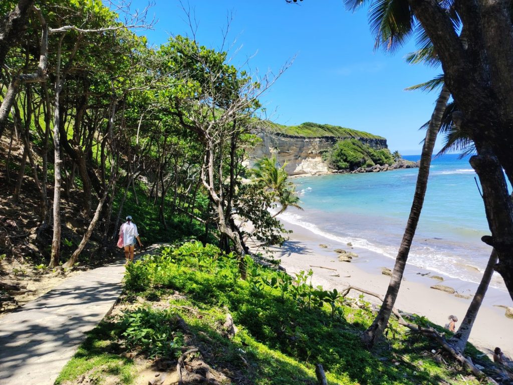
When you've finished photographing the landscape, the wildflowers, and the horizon, Tito will recommend going down to the beach. A steep staircase descends gradually between a limestone wall sculpted by the sea and salt spray, and a tangle of trees and shrubs from the rainforest.
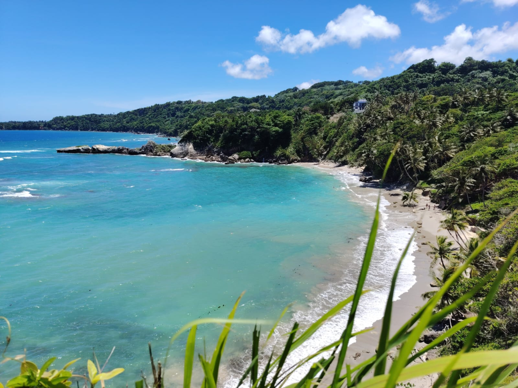
Everything is the product of a whimsical geology that leaves the visitor speechless when they descend the last step and discover the winding shore where fierce waves break most of the time, although sometimes the sea calms down and allows snorkeling to see reef fish and coral bottoms.
This is El Bretón beach, enclosed, yet completely open, between rock formations and embraced by cliffs. As you begin your walk, small freshwater springs appear, flowing down from the forest to the sand, some even forming a channel that visitors know as the "natural shower.".
It's not a long beach, nor is it the kind of picture-postcard spot for mass tourism. Its charm lies precisely in the opposite: being a hidden cove, protected by the terrain and still relatively untouched by aggressive urban development and mass tourism.
When the sea changes mood, the beach takes on a dramatic character: the waves crash with force and the wind transforms the bay into a rugged yet beautiful landscape. El Bretón also marks the visual boundary of the cape, and from the beach, the promontory's walls can be seen rising above the water.
Cabo Francés Viejo, which is part of the María Trinidad Sánchez Ecotourism Route, along with El Saltadero, El Dudú and Laguna Gri Grí, doesn't have zip lines or fancy restaurants, but it has something better: centuries of navigation, history, wind and salt facing an Atlantic that still imposes its rules.
Recommended readings: