

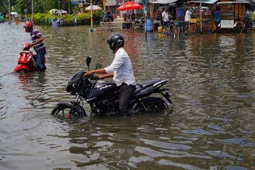
SANTO DOMINGO. – The intense rains, gusts and microbursts recorded in recent days in Santo Domingo were not an isolated event, but part of an increasingly unstable climate pattern that worries local and international specialists such as John Morales, Jean Suriel and Gloria Ceballos.
These phenomena also expose the growing vulnerability of infrastructure and urban developments, in a context of multiple provinces under alert and an increase in extreme phenomena in the country.
The Indomet
The director of the Dominican Institute of Meteorology, Gloria Ceballos, described the weather patterns recorded since the beginning of March as “completely atypical.” She explained that the phenomenon is due to an extreme thermal shock, described as a “cold air bomb,” resulting from the interaction between very low temperatures in the upper atmosphere and warm air at the surface of the Caribbean Sea, which is currently around 27 degrees Celsius.
“The situation that developed in a short period of time resembled a hurricane due to the intensity of the gusts and the rain,” he stated.
The system was composed of cumulonimbus clouds, capable of producing hail and severe winds, and it swept across much of the Caribbean coast, from Bayahibe and San Pedro de Macorís to Greater Santo Domingo and inland areas.
John Morales
The intense rains, gusts of wind, and atmospheric phenomena recorded Monday afternoon in Santo Domingo prompted a serious warning from meteorologist John Morales, who told Noticias SIN that extreme events will become more frequent and intense due to global warming, a trend that is already beginning to be evident in the Caribbean.
On Monday afternoon, within a matter of hours, torrential rains, strong gusts of wind, hailstorms, and abrupt changes in atmospheric conditions were recorded, causing trees, signs, awnings, broken windows, and other damage in various sectors, especially on the southern coast of Santo Domingo.
Jean Suriel
At the local level, meteorological analyst Jean Suriel explained that one of the most dangerous phenomena observed during the episode was a microburst, defined as a column of air that descends rapidly from a storm cloud and, upon impacting the ground, violently disperses in all directions.
Suriel explained that this phenomenon, associated with the trough affecting the national territory and the high temperatures of the Caribbean Sea, can affect very localized areas, less than four kilometers, but with great intensity.
Their duration is usually brief, between five and fifteen minutes, as happened in Santo Domingo, although their effects can be devastating.
“Microbursts can generate winds comparable to those of a high-intensity tornado, with the difference that they blow in a straight line,” explained Suriel, indicating that the gusts can range between 100 and 160 kilometers per hour, and even exceed 240 km/h in extreme cases.
During the event, cloud formations typical of severe storms were also identified, such as cumulonimbus arcus, accompanied by nimbostratus clouds, in addition to visual phenomena such as a double rainbow at the end of the precipitation.
The forecast
The impact of this event is reflected in the most recent report from the Emergency Operations Center, which maintains 19 provinces under yellow alert and 9 under green alert due to the risk of flash floods, river overflows, and landslides.
Among the provinces under the highest alert level are Puerto Plata, Santiago, La Vega, Monseñor Nouel, San Cristóbal, Monte Plata, Samaná, and Greater Santo Domingo, including the National District.
The agency also reported that more than 30,500 people have been displaced, with thousands of homes affected and numerous communities cut off. In addition, more than one million users are experiencing disruptions to their drinking water service due to damage to aqueducts.
In the National District and the province of Santo Domingo, urban flooding was reported on important roads such as 27 de Febrero, Independencia and George Washington avenues, as well as fallen trees and hailstorms that complicated traffic.
Looking ahead to the next few hours, authorities warn that atmospheric conditions will continue to be favorable for moderate to heavy downpours, thunderstorms, gusty winds, and even hail, especially during the afternoon and early evening.
This scenario reinforces the warning from experts like Morales: what were once isolated events are now part of a new climate reality in the region, where the combination of heat, humidity and atmospheric instability is generating increasingly extreme and difficult-to-predict phenomena.
Recommended readings: