

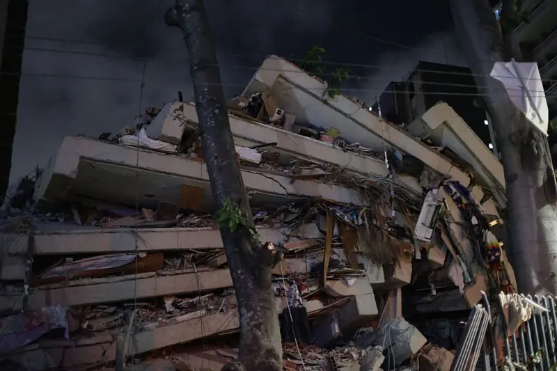
He recommended prioritizing local seismic response analyses, with the purpose of ensuring that buildings can respond adequately to high-intensity earthquakes
SANTO DOMINGO – The recent earthquakes that have shaken South American countries, such as Colombia and Venezuela, have generated concern and numerous questions among the population about what is happening geologically in the region and the world. Given this scenario, several questions arise: Could something similar happen in the Caribbean islands? What is happening on Earth? And what is causing the frequent seismic activity?
Geologist and professor Osiris de León explained to El Inmobiliario that these natural phenomena are produced by the interaction of four tectonic plates, whose movements and forces cause fractures in the rocks of the Earth's crust.
“There are four tectonic plates interacting and competing in the same space. Clearly, there are multidirectional forces that fracture the rocks of the Earth's crust, and every so often, the accumulated elastic energy is released through a major seismic event. From 2020 to the present, we have had five major earthquakes in the region,” he said.
De León stated that the seismic movements recorded in recent years constitute evidence of the pressure exerted by these plates.
“Three of them were in the area near Jamaica, and two more now, between June and August, in Venezuela and Colombia. All of this shows that there is a regional tectonic push coming from the Pacific Ocean, and that is why the western half of the Caribbean has suffered these five major earthquakes of magnitude greater than seven in recent years,” he said.
How many tectonic plates interact in the region?
The geology specialist mentioned that multiple countries are vulnerable to these phenomena due to the interaction of tectonic plates present in the area.
“In our Caribbean region, there are four tectonic plates that interact. The Cocos Plate pushes against the Caribbean Plate, and on the Caribbean Plate are the island of Hispaniola, Jamaica, Puerto Rico, the Lesser Antilles, the northern part of Venezuela, the northwestern part of Colombia, and there the South American Plate and a segment of the Nazca Plate also interact,” he explained.
He calls for strengthening prevention measures

Geologist Osiris De León. (External source).
During his conversation with El Inmobiliario, De León highlighted that some nations considered themselves prepared to face eventualities of this nature; however, recent events have demonstrated the need to strengthen preventive measures.
“Venezuela and Colombia believed they were prepared for a major seismic event, but reality has proven otherwise. Most countries in the world face this reality, because we often fail to prepare for major earthquakes or the impacts of large hurricanes and storms in the region. All of this should lead us, first and foremost, to implement seismic microzonation in every major urban center,” he added.
It recommends prioritizing local seismic response analyses
The professor recommended that both the authorities and those who develop building and infrastructure projects give priority to local seismic response analyses, in order to ensure that the constructions can respond adequately to high-intensity earthquakes.
“Where you are going to build the hospital, you have to do a local seismic response analysis, and with that information, the structural engineer must design the dimensions and distribution of the structural elements so that the structure responds well. But that has to start with the soil study,” he pointed out.
He also added that ongoing work is necessary to ensure better structural safety. “The structure won’t perform well if we don’t know how the soil will respond. And that has to be a continuous effort,” he stated.
Cities that need land-use plans
According to the geologist, cities and municipalities such as Santo Domingo, San Cristóbal, Baní, Azua, Barahona, Pedernales, Bonao, La Vega, Santiago, San Francisco de Macorís, Salcedo, Tenares, Nagua, Río San Juan, Gaspar Hernández, Sosúa, Cabarete, Puerto Plata, Luperón, Montecristi, Castañuelas, Villa Vásquez, Mao, Santiago Rodríguez, Navarrete and Villa González, as well as areas where essential infrastructure is developed, need territorial planning plans that allow for the construction of buildings that are more resistant to earthquakes.
“They need a land-use plan based on seismic microzonation, where hospitals, schools, churches, shopping centers and all buildings that house many people or receive many people for service purposes need a local seismic response analysis to be done in order to design earthquake-resistant structures,” he explained.
The construction code is not enough
De León also warned that compliance with a building code, by itself, does not guarantee that a structure can respond adequately to an earthquake.
“What defines seismic resistance is not a simple code in the Dominican Republic or anywhere else in the world. In Japan , the code has failed. In Chile , the code has failed , in California , in Venezuela , in Turkey , in Colombia , and in Puerto Rico . Therefore, the code is a reference that must be used in conjunction with a local seismic response analysis.”
The specialist insisted that information should not be assumed or extrapolated from one place to another, because soil conditions can vary significantly.
“You can’t assume or extrapolate information. Where you’re going to build the hospital, you have to do a local seismic response analysis, and with that information, the structural engineer must design the dimensions and distribution of the structural elements so that the structure responds well. But that has to start with the soil study.”.
De León specified that the analysis must go beyond determining the load-bearing capacity or the possible settlement of the land.
“It’s not just about identifying the soil’s bearing capacity, the maximum settlement that can occur in the soil, but also about knowing the local seismic response of that soil. And when we are going to build a bridge, an overpass, a residential tower, or a hospital, the first thing we have to do is a local seismic response analysis.”.
Finally, he gave as an example the construction of transport systems on terrain with particular characteristics.
“If we are building a subway on clay soil and it is supported by monopiles, then we are going to do a local seismic response analysis.”.
Recommended readings:
- Is the Dominican Republic prepared for a major earthquake? Expert warns about building vulnerability
- Earthquake in Colombia leaves more than 100 dead, dozens missing and more than a thousand buildings destroyed
- The number of people missing after earthquakes in Venezuela exceeds 64,000; satellites identify more than 430 collapsed buildings